Rapa Nui
Polynesian archaeology
 Island
of Mystery
Island
of Mystery
Easter
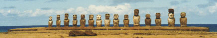
Island, Rapa Nui, is a small island, approximately thirteen by eight
miles, in the South Pacific. It is the most isolated populated island
on Earth, located about 2300 miles west of the coast of Chile and 1200 miles
from the nearest inhabited island, Pitcairn Island where the mutineers of the
Bounty settled. The isolation may have something to do with the frequent
association with the words "mystery" and "secret", but the
primary reason is the moai statues that ring the island and dot the
interior. One can't mention Easter Island and not talk about
them. Read a little about them here. ![]()
Thor Heyerdahl's books introduced this place to me many years ago, and although many of the concepts he wrote of have been superceded by archaeologists like William Molloy, the aura of mystery and discovery I found in those books remains.
The Project
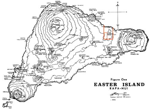
Much of the cultural knowledge of the Rapa Nui people was lost as a result of colonialism and the horrific Pacific slave trade of the 19th century, but because the island is lightly populated and so isolated, a great deal of historical data is retained and readily accessible in the archaeological record. Even a slightly trained eye will recognize that this archaeological record covers the island. In October 1999 I participated in Dr. Christopher Stevenson's Earthwatch project to survey and sample a large area inland of the north coast. For two weeks we mapped individual habitation, agricultural, and ritual sites and features in an effort to understand population and cultural patterns over time. The map above, a reproduction of William Molloy's, has Chris's La Perouse survey area marked in red on the north coast. The smaller red rectangle is the approximate area of our own two-week project.
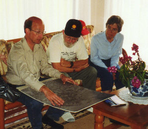 |
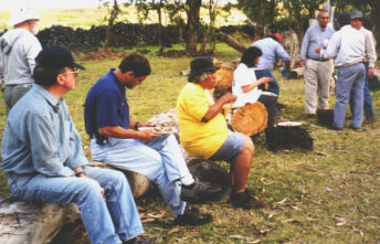
Chris explains the survey process to Carlton and Jean (left) and the rest of the team. He has a set of large, mounted aerial photos that cover the survey area (detail at right). Most large features are visible in the photos. In the simplest terms, a survey group systematically walked over the area, flagging archaeologically significant features. | |
| A smaller measuring team, with Chris then investigated the flagged items, interpreting, measuring, and describing them. Chris would find the site on the aerial photo and record the site number there. | 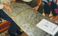 |
|
 |
Our international team of six volunteers began the project with an umu tahu with some Rapa Nui officials. At right, Chris takes some chicken and yams cooked wrapped in banana leaves in a traditional earth oven. The ceremonial meal took place in a corner of the survey area. At left, Barry, Sebastian, and Alex partake while Chris talks to the local participants in the background. | 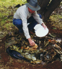 |
 |
We spent most of our time performing the survey, described in detail on these pages, and one morning core-sampling in a previously surveyed area, as described here. |
 |
The purpose of the survey is to gather information on the use of the land over time. The survey itself interprets the surface features and sites over a large area while test trenches provide detailed archaeological context data over the history of occupation for the trench locations. Material from the trenches may also be used for radiocarbon or obsidian dating. Chris will use the information gathered to refine the model he is developing for Rapa Nui society over time. Very simply put, the model has three levels of occupation. 1. Initial settlement was along the coast near the original ahu. 2. As the population grew, inland agricultural plantations were developed with their attendant living sites. 3. Ephemeral settlements on the hill tops increased the available cultivation area. Extensive agriculture was needed to pay for the building and expansion of ahu and the carving and transport of moai. Chris believes a large part of the island was cultivated at the peak of production. Later, as the culture declined, the upland locations were abandoned and the decreasing population moved back down to the coast.
| In addition to the survey, we spent a little time in a lab facility at the Archaeological Museum cataloging artifacts from test trenches dug by earlier teams. In the photo the team is gathered around a large table recording provenience and re-bagging material collected several years earlier. | 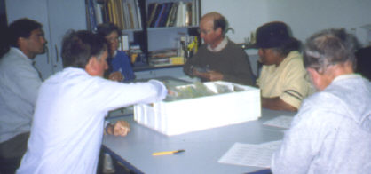 |
|
|
Chris Stevenson's Earthwatch project continued for several seasons. |
|
| I need to add concerns for Rapa
Nui to this account. This small, fragile island cannot support
itself in today's world. Its only income is from tourism and that is
controlled by its isolation and the limited access afforded by a
restricted airline schedule. I wonder how much tourism the island
can support. There are programs to help the Rapa Nui people
but there are doubts about their effectiveness and
appropriateness. The island's history and its archaeological
record inform us of successful and failed agricultural techniques and of
careless squandering of resources. There is a good chance these
lessons of history will not be heeded.
My impression of the Rapa Nui is a proud people, proud of their island and proud of their heritage. I don't think it is my place to tell them what to do, but I do hope their decisions and those of the Chilean government do not trade that unique heritage for a quick and short-lived economic fix. Visit the Easter Island Foundation web site, linked below, for more information. |
| I recommend these books for further reading about Rapa Nui archaeology. Read more about them and/or order them by clicking the title links. |
|
|
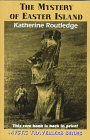
The
Mystery of Easter Island by Katherine Routledge is a reprint of the
1919 volume. This fascinating and nicely illustrated book documents
her travels to and from the South Pacific from 1913 to 1916 including extensive
studies on Easter Island. |
|
|
Easter
Island: Archaeology, Ecology, and Culture by Joanne Van Tilburg
documents her research on Easter Island. In addition to general
historical and cultural background there is speculation about how the moai
were transported and considerable detailed information about individual moai. |
||
| Collapse: How Societies Choose to Fail or Succeed by Jared Diamond is a detailed and interesting treatise about how a society interacts with its environment has a profound effect on its survival. The book includes a long chapter on Easter Island that draws on recent Easter Island archaeology, including Chris Stevenson's project described on this page. Chris is mentioned numerous times in the chapter. Both hard cover and paperback editions are available. |
|
|
| These links will open in a new window: | |
|
|
Visit the Easter Island
Foundation web site for more information about Rapa Nui. The
site also features interesting publications. |
|
|
This PBS
Nova Online
web site includes descriptions of historical and one or two hysterical
theories about moving the moai. The associated program of
Van Tilburg's transport demonstration, Secrets of Lost Empires Part
3, was broadcast in the US in mid-February 2000. |
|
|
|
|
|
Updated 9 May 00.
This page and its contents © Copyright 1999, 2000 Michael & Karen Crisafulli except as noted. All rights reserved.